

Research Vision
Skagit Climate Science Consortium scientists collaborate to make our Skagit-based climate science research integrated, centralized and publicly available through SC².
We meet periodically to share current and prospective research projects, as well as to discuss priority research gaps we believe are important to fund in order to answer key scientific questions or reduce the uncertainty of existing findings regarding climate change and its impacts in the Skagit basin.
Over time SC² hopes to build a website where people can readily find scientific information about climate and potential climate impacts in the Skagit basin and read the original research if they wish to.
First Blush Sunrise, Hidden Lake Lookout, North Cascades National Park
© Wyatt Mullen
Integrated Research
Used to working with complex issues, our scientists began extending their scientific discourse outwards from their specific area of expertise to include other Skagit research scientists. Since 2009, we have realized that our research can more easily capture the complexities of climate change impacts and be more relevant to managers and policy makers if we use each other’s findings to develop, test, and model the components they are interested in.
In this way, SC² scientists are able to do integrated science, supporting our aspiration to build a model from the headwaters to the sound that will describe potential impacts of climate change on the Skagit. This research vision also serves as a tool to identify data gaps and to show how increased funding for critical research efforts contributes to information important to understanding potential climate impacts. By working together in this manner, SC² research projects are stronger because they build on the results of others.
In order to visualize the complex relationships between components of the Skagit system that SC² scientists are studying (for example, the relationship between melting glaciers, reservoir management for energy production, and the need for agricultural water supply downstream), the Consortium has developed a research vision diagram (Figure 1). The diagram shows what data and models are currently being used or are needed to better understand how climate change information at a global level moves through models from the headwaters in the Cascades to Puget Sound.
Along with global climate change information, more localized information on both the physical properties of the river and human needs or effects (like population size and land use change) is also entered into the models. The models themselves take inputs from either data collection efforts (i.e., sediment monitoring) or from other models (i.e., the reservoir model uses the hydrologic model’s outputs as inputs). Scientists then run a series of simulations based on known and/or hypothesized relationships. The models then produce outputs (i.e., predicted flood levels, flows, changes in vegetation, changes in sediment volume and location) that tell the scientists something about how the Skagit River system will behave under different scenarios of future change. These outputs are then tested with real data over time to improve the quality of the outputs.
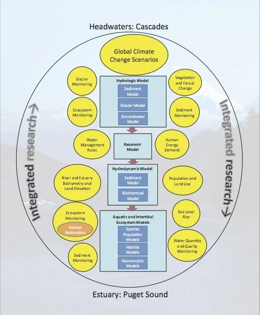
Figure 1. Research Vision Diagram. Yellow bubbles represent information that is either collected by individual SC² scientists, or is available for use from research being conducted by scientists outside SC². This information is fed into the models depicted by the aqua rectangles. Each model in the series going from the top of the diagram to the bottom takes as inputs the outputs of the model above, and gives its outputs to the model below. Models shown in darker blue inside each of the aqua model rectangles are “sub-models,” which feed their inputs directly into the larger model but are not used outside that model. Similarly, orange bubbles shown inside the yellow bubbles depict data that is fed into the set of information being collected under a particular topic. In this way, all of the research being conducted under the SC² vision is integrated across disciplines and is designed to emulate the flow of water from headwaters to estuary.
The diagram is intended to capture SC²’s current research strategy as well as provide guidance for future research development. At present, not all models are fully developed, nor is all of the information depicted in the overall diagram being collected or utilized.
The role of science is to create a hypothesis and then test whether or not the hypothesis is likely true or not. As scientists work to understand the world through their hypotheses, they determine areas of “uncertainty” and work to reduce them through further data collection, modeling or analysis. For instance, the Intergovernmental Panel on Climate Change (IPCC), because of the complexity of understanding the earth’s climate, has relied on multiple groups of scientists with different methodologies and approaches to understanding climate to make future projections. Over time the projections provided by these various scientific communities are increasingly constant in their outputs despite their varied approaches. This is known as “reducing uncertainty.”
While there remain, and always will, several sources of uncertainty in climate models, the IPCC in particular has created robust and scientifically rigorous methods for developing their climate scenarios. It is important for citizens and decision-makers using information and statistics that inform their decision-making to understand the rigor with which findings have been made. For instance, journal articles often undergo an independent review that can help weed out poorly constructed research. Fact sheets and other non-reviewed materials can be less reliable if sources for the information are not provided.