
Rising Sea Levels
The Challenge
As global average air temperatures warm, the base sea level is projected to increase. While sea levels are not currently measured in Skagit Bay, we do know that the waters adjacent to Seattle have risen about 9 inches since 1900. The average sea level in Puget Sound is currently projected to rise about 24 inches (+/– 12 inches) by 2100, though other studies suggest it could rise much higher. While there is broad consensus about the upward trajectory of sea level, scientists are still learning how fast, or slow, change will occur. Regardless, as the base sea level increases, many challenges and risks currently experienced in the Skagit area will likely become more frequent and more severe. For example, part of the La Conner business district is situated over the Swinomish Channel. According to their Town Administrator in 2017, the sub-structure used to be reached by the water only 1 or 2 times every 2 to 3 years. Recently, the water level is reaching the substructure 4 to 5 times every year.
Understanding sea level is complex as the sea level varies a lot, naturally, without any climate change related influence. Indeed, sea level can vary up to 18 inches just based on factors such as El Niño and wind. As many are familiar, storm surge during storm events can significantly elevate sea levels (see Figure 1). We also know that even given large natural variation, small changes in the average annual sea level can have a large impact on storm surge and ultimately on coastal flooding. In fact:
- A 12 inch increase in sea level turns a 100-year coastal storm event into a 10-year coastal storm event
- A 24 inch increase in sea level turns a 100-year coastal storm event into an annual coastal storm event
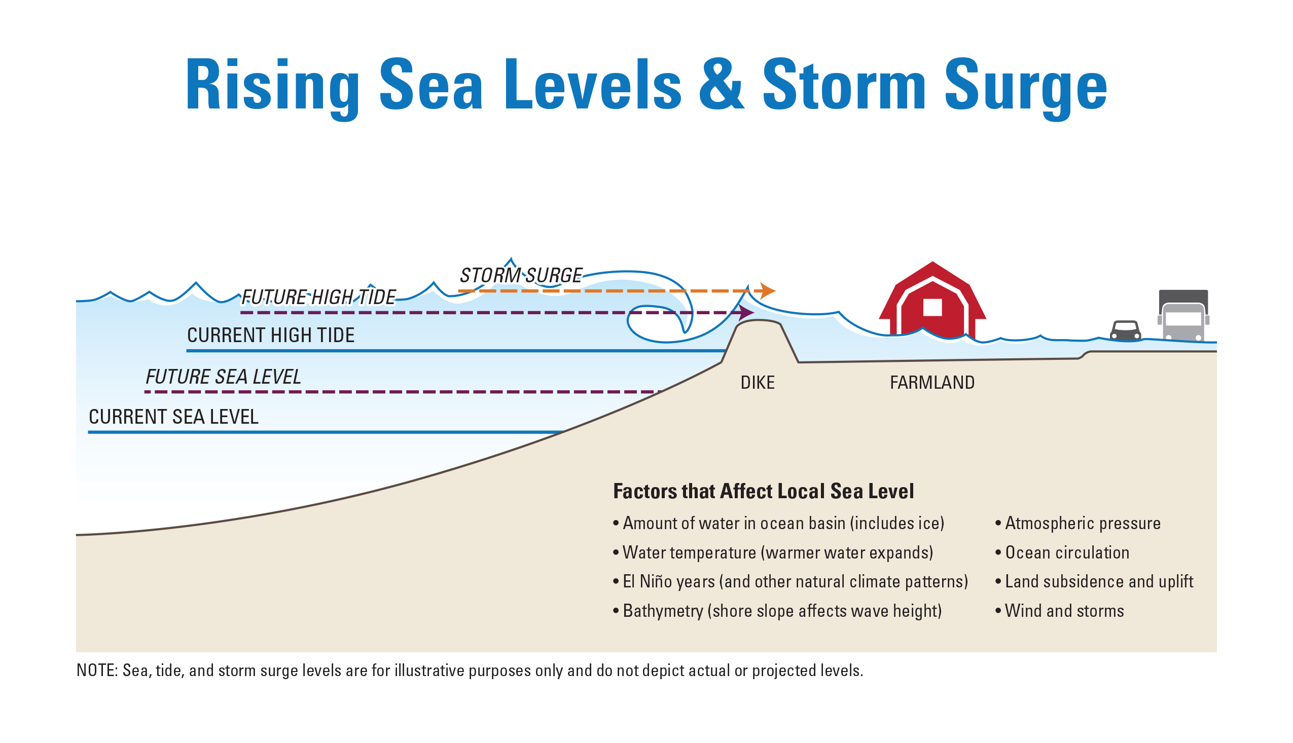
Figure 1.
Sea level has risen in parts of Puget Sound such as Seattle and are projected to continue to rise (Figure 2). Sea levels in Skagit Bay are not currently being measured and this represents a significant data gap, however we do know that the Skagit delta is subsiding (sinking lower) which alone can contribute to a relative rise in sea levels. This is contrasted by the Olympic peninsula which is rising due to pressure between the plates, and is currently off-setting slightly gains in sea levels.
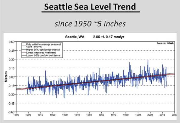
Figure 2. Average sea level in Seattle has risen by about 9.8 inches since 1900. This graph also shows the annual average variance, shown as the ‘erratic’ blue lines, based on a number of factors.
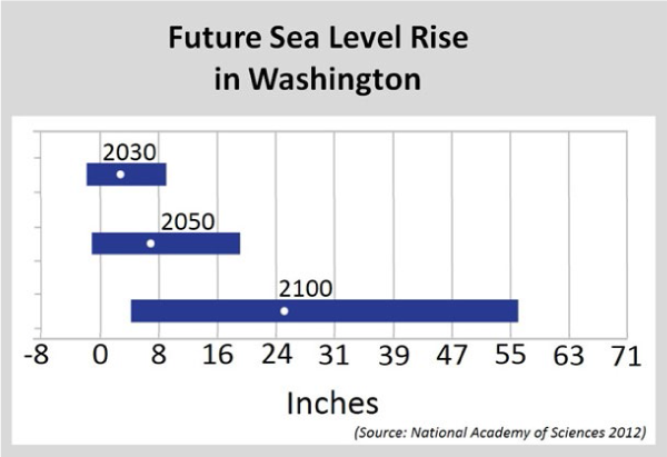
Figure 3.
The implications of rising sea levels in the Skagit region are critical because the Skagit delta is in a low-lying area much of which is currently below the average sea level. Rising sea levels place pressure on dikes, reduce gravity fed drainage of agricultural lands, increase flood implications for Mt. Vernon and the other small cities, affect groundwater, increase damages from storms, and affect other infrastructure and homes.
The Intergovernmental Panel on Climate Change (IPCC) has published global projections of sea level rise. However, translating the global or West Coast projections of sea levels into Skagit-specific projections hinges on multiple local factors, like atmospheric circulation patterns and vertical land movement. For instance, as noted above, in Puget Sound the Olympic Peninsula shorelines are rising whereas the Skagit delta shorelines are sinking.
Coastal Flooding and Erosion
Increases in coastal flooding and erosion are the result of more frequent extreme high tides, higher storm surge, and the greater chance of a high tide coinciding with a flooding river. Sea level and storm surge can cause floodwaters to “back up” into the lower Skagit River potentially increasing the impacts from river flooding. The higher the tide, the less water can be evacuated from the land. Already seawater backs up from the bay to about Mt. Vernon during high tides.
Rising sea levels can cause storm waves to become larger and more likely to overtop dikes and erode coastal bluffs and bulkheads. Flooding and erosion are expected to increase in the coming decades, which may result in more frequent disruptions to transportation corridors and damage to property. Also, key infrastructure such as the City of Anacortes’ wastewater treatment plant lies within areas potentially affected by sea level rise and increased flooding.
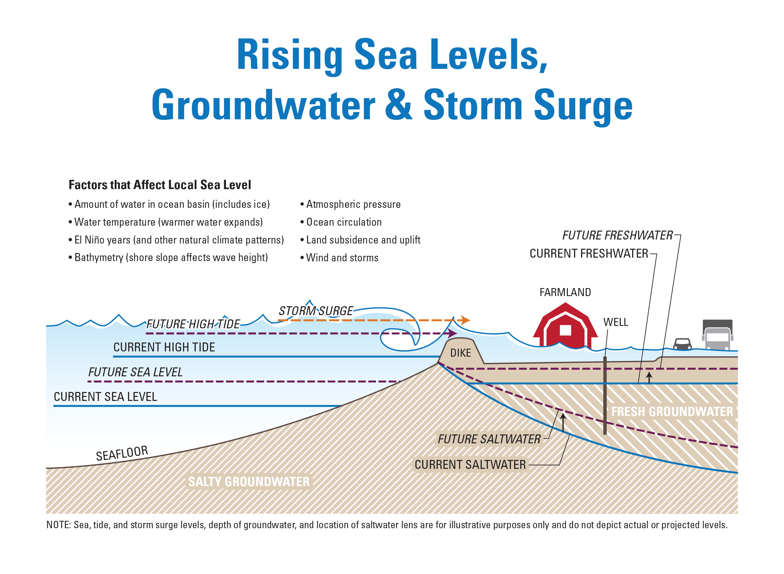
Rising Groundwater Levels
A rising sea also raises the level of groundwater underlying low coastal lands, affecting farmland and coastal septic systems. The lowest farmland on the delta has already subsided below the level of the nearby tidal marsh, located on the bay side of existing dikes and levees. Farm drainage on the delta is also affected, as rising seas may result over time in a greater need for mechanical pumps to drain ditches and keep farm fields from flooding.
Changing Habitats
Coastal habitats will be affected by sea level rise too. Eelgrass meadows, which support a variety of fish, birds, and crabs, may benefit if deepening coastal waters increase the area suitable for eelgrass growth, however, eelgrass is light dependent so it also may not survive in current locations, if depth and sediment change light availability. Tidal marshes are very ‘elevation dependent’ so as sea levels rise, they may drown, especially where dikes, seawalls, or natural topography prevent inland “migration” or movement of these habitats to higher elevations. In addition, higher winter storm waves may also increase the rate of erosion for both marshes and eelgrass meadows and lead to habitat loss.
Sinking Shorelines
Sea level rise is relatively greater in the Skagit area than near the Olympic Peninsula because much of Puget Sound is subsiding, or sinking (Figure 5). Scientists believe the Skagit Delta is sinking between 0 to 1 mm per year as a result of deep subsidence, due to shifting in tectonic plates. Since the regional sea level rise estimates assume 1mm/yr of uplift on average across the whole region, a local subsidence rate of 1mm/yr in the Skagit area may shift the range of sea level rise projections upwards by up to 8 inches or more by 2100 for the Skagit area. River deltas with levees also experience shallow subsidence due to soil compaction, decomposition, erosion, and loss of sediment. As these areas sink, they become more vulnerable to flooding from rising groundwater, another consequence of sea level rise.
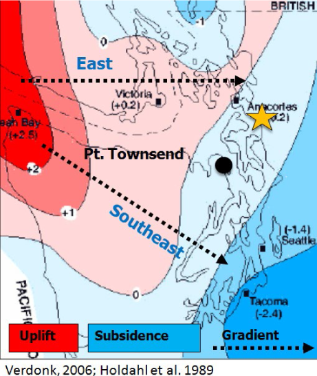
Figure 5. In Puget Sound, the Olympic Peninsula shorelines are rising (“uplift” in red) whereas the Skagit delta shorelines are sinking (“subsidence” in blue.)
The science underpinning global sea level rise projections and estimates of local impacts are rapidly evolving, and more recent studies indicate higher rates of global sea level rise than those discussed above.
For more information about sea level rise, download SC2’s brief overview and infographic on the topic. More information is available in the recent Northwest Science Special Issue articles “Assessing Tidal Marsh Vulnerability to Sea-Level Rise in the Skagit Delta” and “Sensitivity of Circulation in the Skagit River Estuary to Sea Level Rise and Future Flows.”