
Flood Risk: Combining Forces
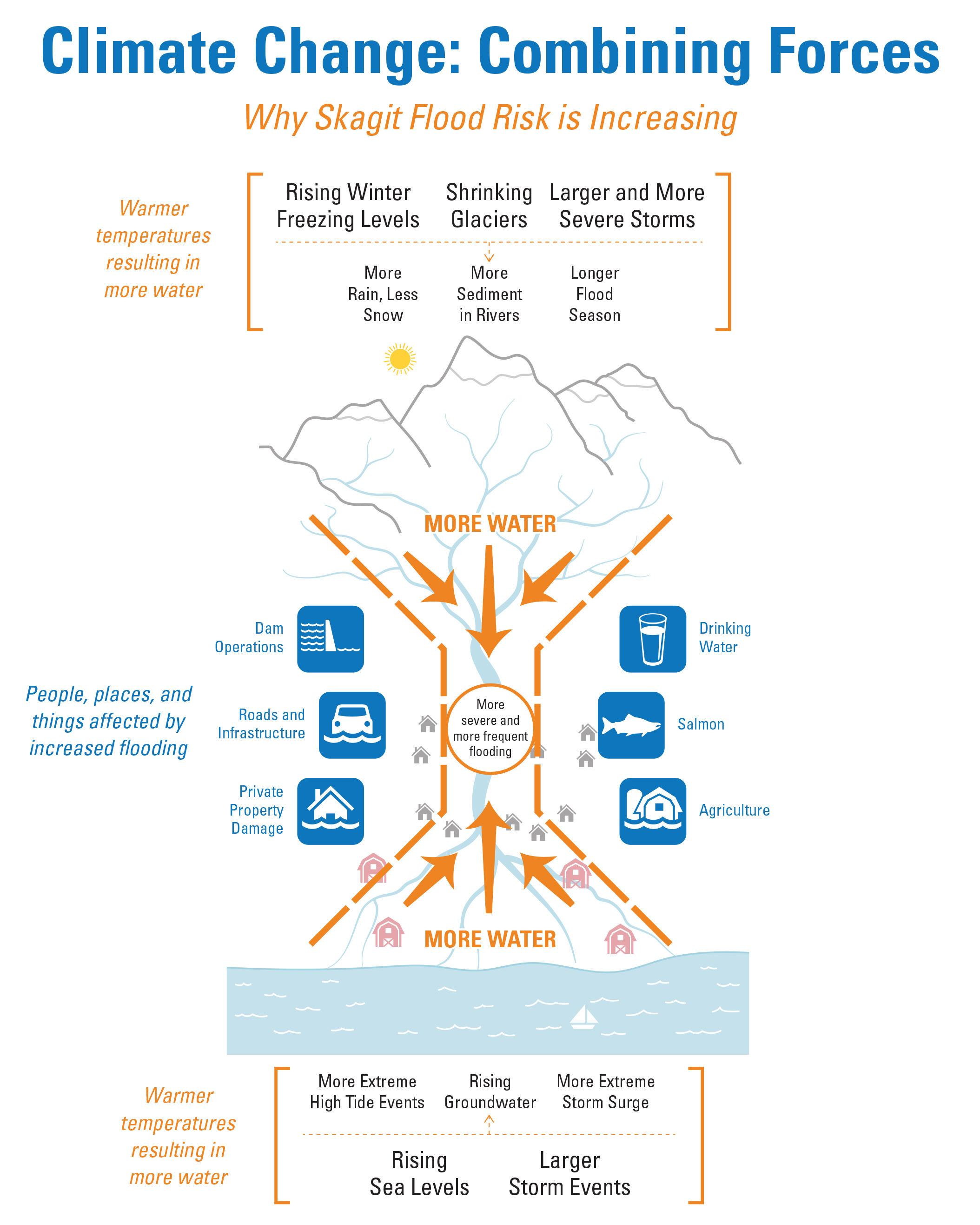
Because of its landscape and geology, the Skagit River is prone to flood even without climate change. The upper watershed covers a huge area of steep slopes and many small streams. Rain and snowmelt flow down the mountains and foothills into three major river branches: the Sauk, Cascade, and Baker Rivers. These branches join the mainstem Skagit River in a narrow and confined valley between Rockport and Concrete, a distance of only eight miles. Much like sand through a two-way hourglass, river flows from the upper watershed and tidal flows coming upstream from the bay meet near Mt. Vernon, Burlington and Sedro-Woolley, resulting in flood events. Dikes and levees on the system only confine water within a channel but are still affected by tidal influence which extends inland close to Mt. Vernon during high tides.
As air temperatures rise, glaciers will continue to melt and shrink and winter freezing levels will rise. As a result of these changes, more precipitation is projected to fall as rain and less as snow, the flood season will extend, and storm events will bring more intense rain. All of these forces loosen more sediment, filling in rivers and tributary streams, and reducing the capacity of the channelized system to carry floodwaters.
At the bottom of the hourglass, sea levels will also rise at the same time river flood levels are increasing. Rising sea levels push groundwater levels closer to the surface and result in more frequent high tides and greater inland surges of water during severe storms. Already, the highest tides of the year are during the flood season. During storm events that cause river flooding, coastal storm surge can also further increase the sea level due to pressure and wind.
The combined forces of more water from the Cascade mountains and the rising Skagit Bay can affect habitat for salmon throughout the watershed. It can also put pressure on existing levees that currently protect farmland, private property, and roads and other infrastructure as water levels in the river flow over infrastructure for more of the winter season.
More resources on flood risk:
- A brief overview (PDF) on “Climate Change: Combining Forces.”
- A PDF of the infographic above.
- SC2’s impact pages on river flood risk and coastal delta flood risks.
- Flooding Photo Visual Simulations
- Flood Risk in the Skagit video
- The recent Northwest Science Special Issue article “Combined Effects of Projected Sea Level Rise, Storm Surge, and Peak River Flows on Water Levels in the Skagit Floodplain.”
- Videos and PDFs of the presentations at an SC2 hosted workshop on November 28, 2012 focused on the combined impacts of projected long-term increases in river flooding and sea level rise/storm surge in the Skagit basin.