
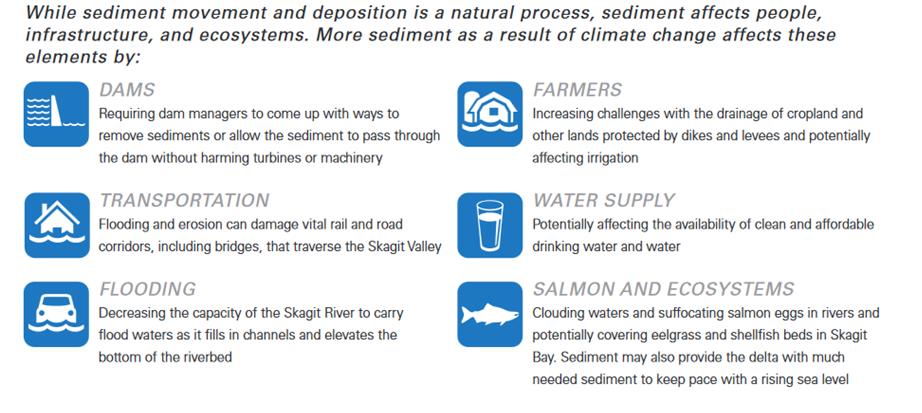
Sediment
Why Sediment Matters
The Sediment Basics
From its headwaters in the rugged North Cascades down to its confluence with the saltwaters of Puget Sound, the Skagit River drains a huge amount of land – 3,200 square miles, which is twice the size of Rhode Island.
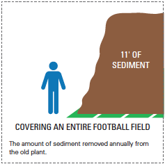
The river carries water, but also considerable sediment: the sand, mud, and pebbles that were once solid rock. In fact, the USGS estimates that the Skagit River transports 2.8 million tons of sediment every year. For example, much of the drinking water in Skagit County comes directly from the Skagit River. Every year, enough sediment is removed, just for drinking water, to cover a football field 11 feet deep in dirt!
This sediment can be carried by, suspended in, or dropped and deposited in channels and Skagit Bay by the flowing waters of the Skagit River.
The Flow of Sediment
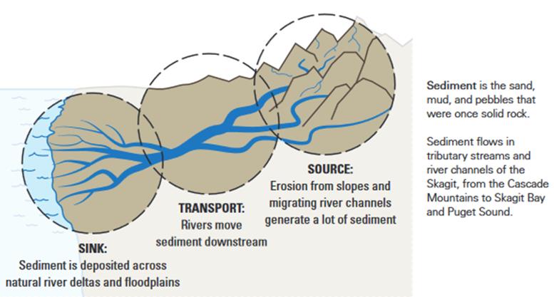
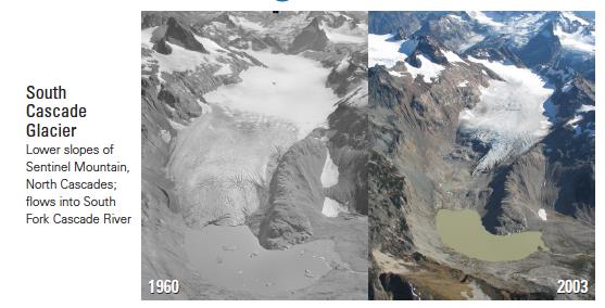
Water and sediments mix, mingle, and scour to define the path and shape of the Skagit River every year. In the mountains, the steep slopes erode and generate a lot of sediment acting as the “SOURCE”. As winter freezing levels increase, winter storms intensity and glaciers retreat, levels of sediment are projected to increase.
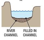
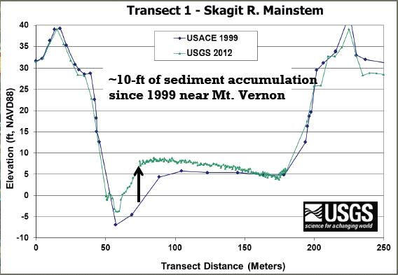
Lower in the watershed, sediment is carried and dropped and carried and dropped by the water in the “TRANSPORT” zone. In the Skagit River, the towns of Sedro-Woolley, Mt. Vernon and Burlington are all in this transport zone. Some sand and gravel fills in river channels between dikes and levees, increasing the risk of flood. Increased sediment also can put pressure on levees as well as bridges during flood events. The figure below shows this conceptually while the figure below that shows what this looks like in one place near Mount Vernon.
In a natural system, sediment accumulates and is deposited across a broad “SINK” area of the floodplain. In the Skagit, sediment is pushed out to the bay and Puget Sound due to river channelization and the extensive levee system. Indeed, since the late 1880s, an estimated 90 million cubic meters of sediment has accumulated in Skagit Bay. This is enough to bury the I‑5 corridor between Canada and Oregon 15 feet deep or cover a football field 10 miles high. The sediment has filled in the deeper parts of Skagit Bay an average of 49 feet and up to 90 feet in some places, and represents a tenfold increase in the rate of sedimentation that occurred prior to constructing levees.
Project Changes and Historical Context
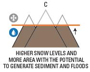
As noted above, warming temperatures are expected to substantially increase the amount of sediment because as the glaciers retreat and snow falls only at higher elevations, less of the upper watershed is covered by ice and snow. Ice and snow help keep the mountains from eroding and sending sediment down the watershed so without it, the amount of sediment increases dramatically. The projected increase in rain storms will compound this issue as the increased sediment is released more frequently and is transported more effectively by higher volumes of water.
Sediment quantities and transport have been significantly transformed by the channelization of the Skagit River, human development, and activities such as logging. Sediment loads are currently 10 times the estimated pre-development conditions and as shown in Figure X are projected to increase significantly with the projected increases in water flows.
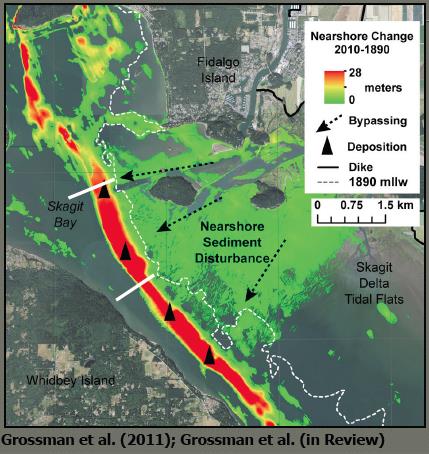
Channelization of the lower river and the construction of dikes and levees downstream changed the flow of the Skagit River, isolating 90% of the Skagit delta from a high flow deposition area as can be seen in Figures Y and Z. Since the North and South Forks of the Skagit River are the only remaining outlets delivering sediments, the rate of deposition in Skagit Bay has accelerated, creating sand bars, infilling of habitats, and blocking drainage infrastructure. This pattern is more striking in the areas near the North Fork since the dominant flow path was diverted from the South Fork in 1937. In addition to increasing deposition of sediments in the areas immediately adjacent to the North and South Fork mouths and Skagit Bay the landward areas behind the dikes have subsided about 3 feet (Haugerud, 2006) creating a situation where humans have to work harder and harder to drain agricultural lands and prevent flooding. Also of importance to people, is that the bayfront marshlands between the two forks are eroding (Hood, 2012) which has significant impacts to the environment as well as increasing risks from coastal flooding.
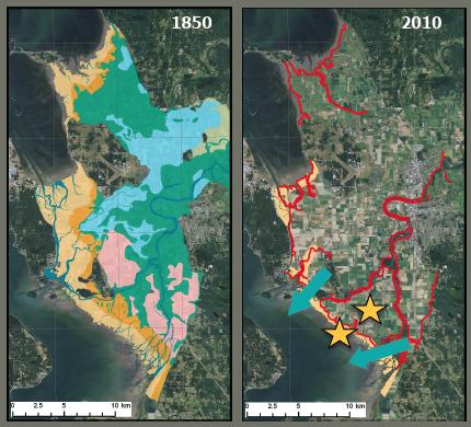
The figures above show the historic delta area that received sediment delivered via the river and the current diked structure that channelizes the river and forces the sediment out to Skagit Bay.
Although overall sediment transport has increased due to development, most sediment that reaches the Skagit Bay bypasses the shoreline/bayfront and tidal flats where they would historically remain, and settles instead in deeper waters. This is shown in the figure below, which shows sediment deposition from the North Fork. Green areas show little relative accumulation of sediment, while the areas in red, further out in Skagit show accumulations of up to 84 feet (please note that the figure uses meters not feet).
Fine sediments are swept away by the currents and settle offshore. The offshore transport of fine sediments as far away as Deception Pass is detrimental to nearshore habitats such as eel grass beds. Important shrimp and crab areas and rock fish habitat are being buried and fragmented by sediment. Already, 60–70% of the eelgrass in Skagit Bay has been negatively impacted. Additionally, fine sediment often carries contaminants that are being dispersed further and further afield.
For more information about sediment, download SC2’s brief overview and infographic on the topic. Dr. Grossman and Dr. Hamlet’s presentations that cover elements related to sediment and sediment can also be found here.
More information is available in the recent Northwest Science Special Issue article “Impacts of Climate Change on Regulated Streamflow, Hydrologic Extremes, Hydropower Production, and Sediment Discharge in the Skagit River Basin.”