Hydraulic Analysis for Floodplain Restoration on the Skagit River near Gilligan Creek
Skagit River System Cooperative: $30,000, from 2009 — 2010
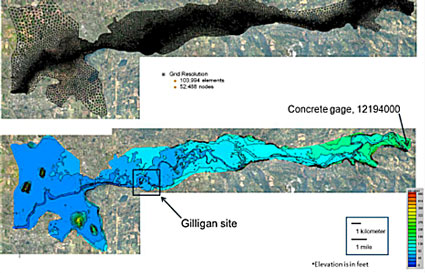
Background and motivation: The Skagit River floodplain includes a parcel owned by the US Forest Service at approximately river mile (RM) 28.5 that is being evaluated for floodplain restoration. At the upstream end of the parcel, a dike composed of riprap was in place for flood and erosion control. The concern is that the dike may be degrading habitat of the floodplain downstream by preventing flood flow into historic swales. The Skagit River System Cooperative (SRSC) has been working with the US Forest Service to develop a plan to restore floodplain processes and the natural habitat at the Gilligan Creek site. A primary component of the proposal is to remove the dike. As a part of the restoration efforts, the SRSC contracted with Pacific Northwest National Lab (PNNL) to conduct hydrodynamic and hydraulic analyses to assess possible floodplain and habitat restoration efforts at the Gilligan Creek site.
Objective: The overall objective of the study was to evaluate habitat restoration potential following various proposed modifications of the flood-control dike. The evaluation included a prediction of the flow conditions in the new channels that could develop in the floodplain from the restoration actions and an evaluation of the possibility for stranding of fish in the new channels. The adequacy of flow in the new channels to sustain and benefit fish was also a consideration.
Project Team: Skagit River System Cooperative and PNNL
Outcome: Hydrodynamic analyses were conducted for three different flow conditions: 72,001 cfs (2,038.8 m³/s), 109,626 cfs (3,103.8 m³/s), and 166,024 cfs (4,700.6 m³/s). The smaller flow is the two year return period flow at the Concrete gate, the larger flow is the maximum flow recorded in October 2003, while the intermediate flow was an intermediate value. The primary conclusion of the analyses was that breaching the dike directed flow toward the southern portion of the site, through the low-lying area to the east and south of the dike. The inundation depths were not significantly different between the existing condition and the alternatives. It was found that the dike modifications did not greatly alter the hydrodynamic characteristics of the swales in which fish habitat improvements are sought.

